Background and Contextual Knowledge of the Narmada District and
a Brief History of both the Sardar Sarovar Dam and Kevadiya Colony
Narmada
District is located in the southern part of the State of Gujarat in India. More
precisely its geographical location is 72.40° to 73.15° East (Longitude) and
21.24° to 22.00° North (Latitude). Narmada District has a total land area of
2,755 km2 and is bordered by the Vadodara District in the north, the
State of Maharashtra in the east, the Surat District in the south, and the
Bharuch District in the west. Narmada District has four talukas (counties)
which include: Nandod, Sagbara, Tilakwada, and Dediapada. The urban center
Rajpipla is located within the Nandod taluka and is Narmada District’s primary
headquarters and main industrial town.


According
to the official 2011 Census released by the Directorate of Census Operations in
Gujarat, the total population of Narmada District was 590,379 with a population
growth of 14.77% since 2001. Narmada District is one of the least populous
districts in Gujarat with a population density of 214 people per km2
and contributes 0.98% to the total population of the State of Gujarat. Table 2
(below) is a summary of the 2011 Census that was conducted by the Government of
India in the Narmada District, Gujarat, India. The languages utilized in
Narmada District include: Gujarati, Hindi, and English.
Table 2: 2011 Census
Data for Narmada District, Gujarat, India*, **
Description
|
Rural
|
Urban
|
Population (%)
|
89.56%
|
10.44%
|
Total Population
|
528,765
|
61,614
|
Male
Population
|
269,709
|
31,561
|
Female
Population
|
259,056
|
30,053
|
Sex Ratio
|
961
|
952
|
Child Sex
Ratio (0-6)
|
940
|
893
|
Child Population (0-6)
|
69,318
|
5,908
|
Male Child
(0-6)
|
35,723
|
3,121
|
Female
Child (0-6)
|
33,595
|
2,787
|
Child Percentage (0-6)
|
13.11%
|
9.59%
|
Male Child
Percentage
|
13.25%
|
9.89%
|
Female
Child Percentage
|
12.97%
|
9.27%
|
Literates
|
328,354
|
49,188
|
Male
Literates
|
190,131
|
26,624
|
Female
Literates
|
138,223
|
22,564
|
Average Literacy
|
71.47%
|
88.30%
|
Male
Literacy
|
81.26%
|
93.61%
|
Female
Literacy
|
61.31%
|
82.76%
|
*Of the total
population of Narmada District, 90% is composed of the tribal villages and the
majority of the tribal villagers live on or below the poverty line.
**The 2011
Census Data and Statistics are a representative of Narmada District as a whole
and is not a representative of the tribal populations of the Satpuda Region.
The main industrial sectors of this
region include: textiles, food and agricultural production, and chemicals. However,
the major stratum of the population—the rural population—is dependent upon
agriculture for their primary source of income (especially during the monsoon
season). Both banana and cotton are the main horticulture crops within Narmada
District. In more urbanized settings, industries producing textiles, sugar,
chemicals, wood products, paper, and food products, as well as repair and
services are prevalent and are the drivers of the urban economy.

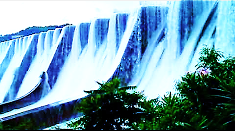
There
are five main rivers that flow through the Narmada District: the Narmada, the
Karjan, the Main, the Ashwini, and the Tarap River. In order to provide more
water to irrigate more than 18,000 km2 of land in Gujarat—especially
drought prone areas of Kutch and Saurashthra—and generate additional electric
power, the Sardar Sarovar Dam was built on the banks of the Narmada River. This
project was undertaken based on its potential to: (1) feed up to twenty million
people, (2) provide both personal and commercial water use for at least thirty
million people, (3) provide temporary sources of employment for the
construction of the dam for about one million people, and (4) provide valuable
and necessary peak electricity to areas of critical and high unmet power supply
demand. This project was undertaken by the Government of the State of Gujarat.
To house approximately one million employees working on the Sardar Sarovar Dam,
the Indian Government produced multiple housing complexes which grew and took
form of a small, flourishing urban town known as Kevadiya Colony.
After
the completion of the Sardar Sarovar Dam, much of the inhabitance of Kevadiya
Colony left to seek employment elsewhere; however, the people who had started
up small-scale businesses in Kevadiya Colony remained allowing the small urban
town to continue to flourish. Currently, a number of the housing units in
Kevadiya Colony remain empty; however, many of housing courters are occupied by
Sardar Sarovar Dam maintenance workers, government employed officials, police
department officials and recruits, small business owners, nongovernmental
organizations (including Anoopam Mission’s Project ASHA staff and medical
professionals—who are offering their services to the surrounding tribal
villages).