Photo Diary for Week
2 ~ The Narmada Sardar Sarovar Dam
ATTENTION READERS: After viewing the pictures, please select the pictures that you liked the most and let me know via the comment box located below the posting...Thank You!
 |
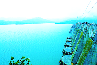
| The elegant beauty of the Sardar Sarovar Dam on a quiet, peaceful day... |
 |
| A map of the three states of India--Madhya Pradesh, Maharashtra, and Gujarat--in which the Narmada River flows through before merging into the Gulf of Khambhat of the Indian Ocean. |
 |
| A more detailed map of the states through which the mighty Narmada River flows through and the location of the Sardar Sarovar Dam site. |
 |
| An even more detailed map showing the location of Narmada River basin in the three states of India that it traverses through as well as the location of the Sardar Sarovar Dam in relation to the other dams built along the Narmada River. |
 |
| The monks, initiators, and volunteers of Project ASHA near the memorial of the late Sardar Vallabhabhai Patel. |
 |
| The front view of the Sardar Sarovar Dam when the water reservoir behind the dam is not full to maximum capacity. |
 |
| The reservoir behind the Sardar Sarovar Dam is at maximum capacity. The collected water is being gradually released and is spilling over the top surface of the dam. |
 |
| A view of the Sardar Sarovar Dam from an observation deck during the monsoon season. |
 |
| A view of the Sardar Sarovar Dam from below during the monsoon season. |
 |
| Another view of the Sardar Sarovar Dam from a more distant observation deck during the monsoon season. |
 |
| A front view of the Sardar Sarovar Dam at an observation park created for visiting tourists and admirers of the dam. |
 |
| A view of the observation park in front of the Sardar Sarovar Dam in the morning during the summer season. |
 |
| Another view of the observation park. |
 |
| A front view of the Sardar Sarovar Dam from the observation park during the summer season when the water reservoir behind the dam is about half full. |


No comments:
Post a Comment